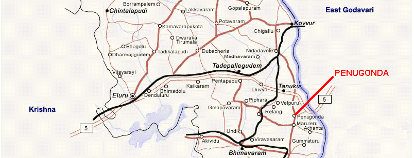
Route Map

Reaching Penugonda
The state of Andhra Pradesh is a located along Bay of Bengal in the southern part of Indian Peninsula. As Andhra Pradesh is a major tourist destination in India. Andhra Pradesh is well accessible by air, rail and road.
There are four major airports in the state Hyderabad, Visakhapatnam, Tirupathi and Putabarti. Other airports in the state running domestic flights are located at Warangal, Rajahmundry, Vijayawada, Kadapa and Donakonda.
Rail provides another good mode of transportation for reaching Andhra Pradesh from other parts of India and travelling within the state. There are more than 200 railway stations in the country.
Roads in Andhra Pradesh are in much better shape than other states in India. Major modes of road transport are buses, tourist taxis, cars, and local taxis. State is connected with other parts of South India by a number of National Highways.
How to Reach Penugonda
You can reach Penugonda, West Godavari District via Road or Rail Network. The Vijayawada Airport is a 130 km drive from the Penugonda. 35 km from Tadepalligudem Station / 30 km from Nidadavole station / 15 km from Palakollu Station
Buses that ply to Narsapur from Hyderabad, Vijayawada, Tirupathi, Vizag, Rajahmundry, Nidadavole.
The Rail and Road facilities in the state links West Godavari District very well with all major locations internally and externally.
